Monday, September 24, 2018
Nearmap Releases Imagery From Hurricane Florence
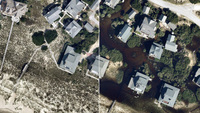 South Jordan, Utah-based aerial mapping provider Nearmap said today that it has released new aerial imagery of North and South Carolina, in areas that were impacted by Hurricane Florence. The companhy said its maps cover 4,530 square kilometers around the coastline from Newport, N.C., to Myrtle Beach, S.C., covering a population of about 752,000 people. The company is offering up the images to public safety organizations, utility companies, and insurance agencies, who use those images for damage assessment and other efforts. Nearmap said its imagery allows its customres to see things like roof blow-off, property damage and flooding, and both pre- and post-disaster imagery. Pricing on the new imagery was not announced. Nearmap has posted some examples of the imagery available through its service.