Wednesday, February 25, 2015
DigitalGlobe's High Resolution Play At Aerial Images
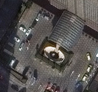 In a bid to display the use of aerial imagery taken from airplanes and helicopters, Longmont, Colorado-based DigitalGlobe said today that it has rolled out full availability of its 30 cm satellite imagery products. Those images--captured by DigitalGlobe's WorldView-3 satellite--were made possible by a rule change by the U.S. Government in 2014, after a lobbying effort by DigitalGlobe. Satellite image resolution has long been restricted to protect national security interests. DigitalGlobe said its high resolution 30cm images have a wide range of uses in the civil government, defense and intelligence, energy, mining, and global development sectors, particularly in replacing aerial imagery for those customers. That aerial imagery is much more expensive, takes longer to acquire, and often cannot be obtained due to access to certain parts of the globe. 30cm, or roughly 12 inches, is the size of each pixel in those satellite images. 30cm is enough that satellite images can show manhole covers, building vents, fire hydrants, and overhead power lines--not to mention to discern the model of an automobile in an image.